The Course
Ramsey Hairpin and the Mountain Climb
The hardest part of a TT lap: the Ramsey Hairpin, the climb through Waterworks and the Gooseneck to the Bungalow and Hailwood's Height.
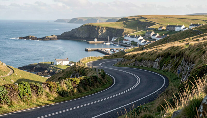
The mountain section is the part of the TT course that most clearly separates road racing from anything held on a permanent circuit. It begins at the tightest corner on the lap, climbs through a series of linked bends, crosses the highest point of the course, and then falls back toward Douglas. Weather, gradient and surface all change within a few miles. This guide follows the climb from Ramsey to the summit.
The Ramsey Hairpin
The hairpin at Ramsey is the slowest corner on the Mountain Course and the tightest. The road doubles back on itself on a gradient, between walls, in the middle of the town. Riders arrive from the Sulby straight and the fast approach through Parliament Square, brake hard, and negotiate a turn that can be taken at little more than walking pace relative to the rest of the lap.
Because it is so slow, the hairpin is one of the best places to watch a rider work. Body position, clutch control and the moment of opening the throttle are all visible. It is also a place where time can be lost permanently, since the climb that follows offers few chances to recover a poor exit.
Waterworks and the first climb
After the hairpin the course climbs through Waterworks, a series of bends that lift the road away from the town and onto the hillside. The gradient is steady and the corners are linked, so the section is ridden as a single flowing movement rather than as separate turns. A rider who gets the first bend right carries speed through the rest, and a rider who gets it wrong fights the hill.
Waterworks also marks the change in landscape. The town falls away, walls give way to hedges and open ground, and the weather becomes less predictable. Even on a fine day in Douglas the summit can be in cloud.
The Gooseneck
The Gooseneck is a pair of bends that climb steeply and turn hard, one after the other, on a narrow road. It is a place where a rider must brake, turn, and accelerate while still on a gradient, and it is regarded as one of the technical highlights of the course. The corner is popular with photographers because the road twists visibly through the frame and the machines are close.
Spectators who stand at the Gooseneck see a different kind of skill from the one on display at Bray Hill. There is less outright speed and more precision, and the penalty for a mistake is immediate.
The Bungalow and Hailwood's Height
Above the Gooseneck the course reaches the Bungalow, a landmark on the mountain road with a station on the Snaefell Mountain Railway nearby. From there the road continues to the highest point of the circuit, Hailwood's Height, near the 31st milestone, at about 1,385 feet (422 metres) above sea level. On a clear day the view takes in much of the island, including the road already travelled.
The summit is exposed. Wind, rain and low cloud can arrive without warning, and the temperature is often several degrees below the coast. Riders and spectators alike treat the mountain as its own climate, and race schedules have been changed more than once because of conditions there.
There is a second reason the mountain matters beyond the weather. It is the only part of the course where a rider can see a long way ahead and a long way behind, and it is the only part where the landscape reveals the scale of the circuit. From the higher bends the road can be traced across the hillside, and the villages and coast far below show how far a lap has already travelled. That view is part of why the mountain section is photographed so often, and part of why it is so demanding to race: the rider sees the whole descent waiting, and the summit is only the beginning of the second half of the lap.
Fuel and brakes are also tested here in a way that the lowland sections do not test them. The climb asks the engine to work against gravity for several miles, and the descent that follows asks the brakes to shed speed repeatedly without overheating. A machine that is merely adequate elsewhere can become a handful on the mountain, and reliability over six laps of a Senior TT depends on the parts that are stressed here.
Windy Corner and the start of the descent
Past the summit the course begins to fall. Windy Corner is named for the exposure rather than the shape of the bend, and it marks the point where the descent toward Douglas becomes continuous. From here the road drops through open country, and the character of the lap shifts from climbing to braking.
The descent is covered in the guide to Creg-ny-Baa and the run to the finish. Together, the climb and the descent make up the part of the course where the island itself is most visible to a visitor.
What to watch for on the mountain
The mountain rewards a spectator who is prepared to walk and to wait. The hairpin offers the closest view of rider control. The Gooseneck offers the best combination of technical cornering and photography. The Bungalow and the summit offer the landscape, the railway and a sense of how large the circuit really is.
Practical notes on access, timing and the weather are in the guide to where to watch the TT. The full order of the course is in the index of named corners of the Mountain Course, and the circuit as a whole is described in the guide to the Snaefell Mountain Course. The geography of the mountain road and its summit is documented at Wikipedia.
The mountain is the part of the TT that visitors remember longest, not because it is the fastest but because it is the most unlike anywhere else. A road that carries commuters and sheep for most of the year carries racing machines over a summit in June, and the contrast is the whole story.